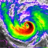
Models included in spaghetti graphics include: HWRF, HMON, CTCX, AVNO, SHF5 & OFCL. NCEP / EMC Cyclogenesis Tracking Products - 16-day Storm Forecast Tracks - 35-day Probability of Formation CIMSS Tropical Cyclone Products - Wind Vorticity & Shear Analysis - Steering Layer Analysis - Morphed Integrated Microwave Imagery - Advanced Dvorak Technique (ADTV9.0) ADT Includes imagery, wind radii estimates & trends Interactive Hurricane Tracker Map - Track & Intensity Forecast - Preliminary Best Track Analysis TERMS & CONDITIONS https://lwbrandsllc.com/hurricane-app-terms-conditions/ -- In total, there are now over 100+ hurricane / weather tracking products to help you stay informed during hurricane season.

National Hurricane Center Data
View in App StoreGrow your in-app revenue
while we take care of your subscription management.
Mobile
SDK by Qonversion.
Price Intelligence based on:
213,534
apps aggregated
8,172,290
in-app prices defined
89
main categories
In-App Purchase Price (Subscription or Non-Recurring)
vs. average for the Weather category, $, by region
Build, analyze, and grow in-app subscriptions
with the most powerful mobile SDK for subscriptions
User Reviews for National Hurricane Center Data
BETTER THAN 5 STARS!!!
How do I love thee app, let me count the ways :)This app is so easy to use. As others have said, the developer took free information, put it all in one place, made it easy to navigate, and doesn’t charge for it. Who is this person or people? Don’t they know that they should charge a lot of money for this? Seriously, I would gladly pay money - a one time purchase - for this app. GREAT feature: the developer puts a note on pages. For example, today we are watching hurricane Laura approaching land. He / she / they have a note explaining that the website is getting so much traffic that it will probably load slow, just wait and it will load. And this app is FREE. I am learning from the notes, I am getting all the information I need, and this app is FREE. I think everyone should have this app, and check out the other apps by this developer! I now have 4 apps from this developer, did I mention that most of them are FREE. Yep I kinda like this app.
App is getting better all the time.
I wrote an earlier review that was less than positive. Soon after I was contacted by the developer. He is working hard to make this app one of the most useful hurricane tracking apps available. One update has been added; another is on the way which allows users to keep informed with potential storm developments. We’ll check back here again when there is a named storm. Thanks for the improvements. The developer’s willingness to listen constructively is an added bonus!Go to Settings and find a direct link to the National Hurricane Center website. This is a real plus. This app just keeps getting better.
New user to this app
We live in the midwest, own 2 houses in St. John, USVI. We were hit hard 2 years ago and have been using the NHC NOAA website daily during hurricane season. Just found this app today. I like the different map views. They provide quick and easy differentiation to multiple aspects. Also works well over the mainland. I would like to see these maps in action for the next official hurricane. I had no issues whatsoever giving 2 bucks to the store. 2 suggestions: Larger Atlantic overview if possible. All these storms originate from the African coast and I couldnt see that area very well; also it might provide a larger picture if the app would rotate to landscape view when i turn the device sideways. Thank you to the developer for all the work you have invested.
Ok...not great.
This app is marginally better than going to the NOAA website. Push notifications are nice. Satellite page loads all of the loop images before displaying. What if i don’t want the loop? I have to wait for all the images to load? What if i have a slow connection? The interactive map is beta quality in my opinion. It takes forever to update; you need the eyes of a five year old to read the minuscule fonts on the storm. Oh, you can zoom in and read it just fine....that is until it updates then back to the fonts for ants. Tapping on the storm does nothing; does not bring up any info. I would pay $20 to get Hurricane Pro or an equivalent app back. So far I have found nothing that even comes close. Some features in the latest version of this app may be worth $2 for some. For me only because nobody can seem to put out anything better.
Can’t live without it
As someone who lives in a hurricane prone state and has lived through a cat 5 storm, I was thrilled when NOAA came out with this app so that I can find all the data I need in one place. The radar images are particularly stunning and the forecast information provides enough range to make educated decisions about timing of evacuations and such. I also don’t have to hear overdone weather forecasters hyping situations up (though, in fairness, it’s not a real hurricane until Jim Cantore appears on screen fighting the elements ;-) ). I appreciate that I can get basic data at a glance as needed and do deep dives into the science when I’m curious. If you want an app that gives you no nonsense information, this is the place to find it. (If spaghetti models terrify you, however, stick with something more basic.) Thanks NOAA et al for this fabulous app!
Best app ever!
I love this app it shows me everything I need to know as a “Cattle Ranch owner “ and even things I just want to know. If my generator dies and I need another one quickly ,I can purchase one quickly right here .Plus the creator is so polite & actually provides a handy place to purchase whatever you might need when you learn the one that you were going to use - won’t work any longer! And your local stores will more than likely be sold out of by the time this happens. Thank again for this great , Free , app- it’s the 5 star best! Living the dream ,Florida native
The Best Hurricane App
I live on the Gulf Coast in Mississippi. Hurricane Katrina destroyed my whole neighborhood when it hit. I rode out hurricane Camille in 1969 when I was a child. I’ve been through all the Mississippi Gulf Coast hurricanes since the mid 1960s. That being said-This app is hands down the greatest tool for understanding these incredible storms. I love the hi-res satellite photos, radar animations, And frankly more data than I am capable of understanding. It’s a wonderful tool with all the available filters on the radar images, I didn’t realize there were so many ways to look at storm data. Try it, you’ll be impressed with what’s available with this quality app.
My GO TO Hurricane app
I have been using this app for a couple of years and have been extremely pleased. Living in Florida and having a home on the water can be stressful in the event you need to evacuate. This is the only app I use to get right to the facts and alerts without scrolling through a lot of unnecessary garbage. Plus it updates very quickly and has all the information needed. I would highly recommend this to anyone wanted to stay up to date on tropical weather systems. In fact, most of my friends have started using it after they see how user friendly it is and how the current information is easy to find.
Great app and getting better with every release!
I’ve been using this app for a while now. Originally, I was just looking for a way to view NHC images easily on mobile. Their web page isn’t the greatest on a mobile browser. When I found this app, it was exactly that. Not many features at that point, but it worked well and was easy to navigate. Basically, it just had the images along with a radar. Every release since then has improved the app and there is now so much interesting information. If you live in an area where paying attention to hurricane forecasts is important, there isn’t a better app!
GoTo App for Hurricane Forecasts and Tracking
This is an excellent app for watching models of approaching storms. Forecasts can change during the course if a storm but these are generally very reliable and it’s not surprising (though it probably should be) how close some long range forecasts turn out to be. I routinely check it for 16-day storm forecast tracks and the 16-day GPS model to get an idea if anything is brewing out in the Atlantic. These are well in advance of reports by any weather service. It has numerous forecasts and models (probably more than anyone could want or need). I love it!!!
Description
Download the most comprehensive Hurricane Tracker app for iOS. MAIN FEATURES INCLUDE: + GOES Satellite Imagery Animations + National Hurricane Center Products + National Weather Service Alerts + Weather Prediction Center Graphics + Tropical Weather Push Notifications + Satellite Imagery Home Screen Widget + Spaghetti Models GRAPHICAL PRODUCTS INCLUDE: Forecast Graphics - Spaghetti Models - 5-Day Tropical Weather Outlook - 2-Week Global Tropics Hazards Outlook - 3-Day Excessive Rainfall Outlook - 7-Day Quantitative Precipitation Forecast Storm Specific Graphics - Key Messages - Cone Track Forecast - Tropical Storm Wind (Most Likely) - Tropical Storm Wind (Earliest) - Hurricane Wind Probability - Surface Wind Field - Surface Wind Analysis - Wind / Track History - Rainfall Forecast - Flash Flood Risk Local Storm Threat Graphics - Flooding Rain Threat - Wind Threat - Surge Threat - Tornado Threat - Rainfall Totals - Wind Warnings Note: Local threat graphics are typically not available until shortly before storm landfall. TEXT PRODUCTS INCLUDE: - Tropical Weather Outlook - Forecast Advisories - Public Advisories - Forecast Office Discussion - Local Statement (HLS) - Local Warnings (TCV) - Tropical Discussion - Wind Analysis WEATHER MAP OVERLAYS INCLUDE: - Hurricane Track & Intensity - Potential Storm Surge Flooding - NASA Sea Surface Temperature - NOAA Weather Radar GOES SATELLITE IMAGERY INCLUDES: Fifteen (15) Satellite Imagery Filters - Visible (Band 2) - Near IR (Bands 4 & 5) - Infrared (Bands 7, 8, 9, 10, 13, 14 & 16) - Nighttime Microphysics - Day Cloud Phase - True Color - Air Mass - Sandwich APPLE WATCH APP INCLUDES: - View wind speed & intensity updates every 30 minutes - View the latest satellite imagery - Choose from a variety of Watch Complications -- PRO SUBSCRIPTION FEATURES -- Full Screen, High Resolution Satellite Imagery: - Latest Image - Animated Loop - Mesoscale: Near Real-time Imagery - Geostationary Lightning Mapper (GLM) Mesoscale imagery typically has 1-minute temporal resolution, but is not always available for each storm. 16-day Weather Forecast Models: - Global Forecast System (GFS) - Global Ensemble Forecast System (GEFS) - North American Ensemble (NAEFS) Weather Simulation Forecast Models: - Hi-Res Rapid Refresh (HRRR) - Hi-Res Ensemble Forecast (HREF) - North American Mesoscale (NAM) - Hi-Res North American Mesoscale (NAM-HIRES) - High Resolution Window (HRW-FV3, HRW-ARW, HRW-ARW2) - WaveWatch III (WW3) - European Centre for Medium-Range Weather (ECMWF) HMON & HWRF Hurricane Forecast Models Experimental Forecast Animations: - Simulated Radar 2km - Surface Pressure, Wind - 200mb Temp, Ht, Wind - 700mb RH, Ht, Wind - 850mb Vort, Wind, Thick Model Analysis & Guidance Animations: - 6h Total Precipitation - 10m Wind - 200mb Vort, Wind, Ht - 500mb Relative Humidity - 700mb Vort, Wind, Ht - 850mb Vort, Wind, Ht Static Forecast Products - Track* - Intensity* - Pressure* - Rain - Wind * Track, Intensity and Pressure graphics include spaghetti plots when available.
More By This Developer


You May Also Like


POWER SUBSCRIPTION REVENUE GROWTH
