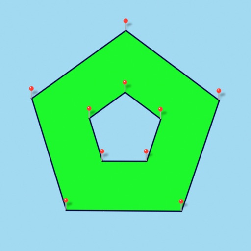
Points can be labeled, saved and shared in KML format. This measurement app is useful for outdoor activities and can be used as land surveyor by amateurs and professionals in various industries like sport, farming, landscaping, paving and construction, road building and repairing, real estate business, hiking and travel, fencing, lot building and planning, solar panel installation (roof area estimation), object mapping, lawn design, and many other where land area and distance / length calculations, land survey or maps are involved. If you have any question about Planimeter and its functionality, please check How To Use Quick Guide: http://ios.vistechprojects.com/Planimeter_iOS_QuickGuide.pdf Video Demo: http://youtu.be/unjYbPCIYM0 http://youtu.be/QQMilHVD5e8 Features: Accurate distance and area calculation Metric and Imperial units (m, km, feet, yards, miles, ha, acres) Angle between lines Bearings To and From the point Forth and Back navigation through points by touch on Info Panel GPS coordinates of a point GPS accuracy settings (if GPS available) Manage previously saved projects: open, save, share KML files KML files created by Planimeter can be imported to GEarth and GMaps to view on a desktop Send data by email: picture, coordinates as text message, KML file Save KML or TXT in local storage Map/Satellite View Zoom and Edit points Current location search Text (address) search Delete selected/last/all points Zoom to Fit-in and center points on a screen - quick points search Add points by touch Add current location as a point Show location with Latitude and Longitude coordinates Add points by Geo-coordinates: Lat and Lng Option to center last point added Option to show/hide lines Preferences: location accuracy, tracking time interval, delete points confirmation, sound option for tracking Separate units settings for distance, area, perimeter Target Mode for accurate pin placement Show current coordinates in Target Mode Stylus Draw Mode Full-screen option GPS TRACKING Manual pin placement in GPS Tracking The app has been successfully used in different areas: - outdoor activities: sports, golf (distance between two points or holes), bike tours, trail planning, travelling, quick path measure - garden and yard: landscape planning, grass cutting, lawn care and mowing, fencing, grass seeding. - agriculture, poultry and farming: harvesting, fertilizing, crops (corn, wheat, maize, beet, etc.) planning and estimation, field area measure, paddocks and area fencing for cows, horses, chickens, rabbits, etc. - solar energy: area estimation for solar panels, flat roof area estimation - construction: land survey, road sealing, parking lot repairing - forestry: objects and tree mapping, damage area estimation, measure land area - other: ponds size and are measure; pole lines planning; movement tracking; get exact GPS coordinates of way-points; fence calculation; geocaching. Note: Continued use of GPS running in the background can dramatically decrease battery life. If you like the app and find it useful please support us with your feedback and comment. Feel free to contact [email protected] with any questions, comments or bug reports.

Planimeter GPS Area Measure
View in App StorePlanimeter GPS Area Measure
4.2
Age Rating
4+
Seller
VisTech.Projects LLCGrow your in-app revenue
while we take care of your subscription management.
Mobile
SDK by Qonversion.
Price Intelligence based on:
213,517
apps aggregated
8,172,290
in-app prices defined
89
main categories
In-App Purchase Price (Subscription or Non-Recurring)
vs. average for the Productivity category, $, by region
Build, analyze, and grow in-app subscriptions
with the most powerful mobile SDK for subscriptions
User Reviews for Planimeter GPS Area Measure
Good for walking field boundaries
I find this app works well in documenting field boundaries for agricultural purposes. It matches my handheld high-precision Garmin unit very well on reasonably clear days and does a faster job of documenting areas via screenshots. I like that it will export the raw data points too. On cloudy days with worse GPS signal, I still need to use the smaller handheld hardware unit.
Multiple sections
I’m currently trying to divide up in thirds (approx 8.3 acres each) 25 acres along a partial of land that is road side on one side and a creek running diagonal across the back. I would like to be able to keep highlighted each 1/3 as I move and adjust the pins so that to keep track of the boundaries and find my layout to make the equal division of land. Makes sense ??
Great app
Overall what I’m looking for. Will work great for my lawn service business. The only option I really would like to see added is an address search function, that would help having to look up a property in another app to find lat & long, then back to this app.
Best I’ve found but not the best it could be.
What this app does is highly valuable. How it does it could be better. I wish it would zoom in more than it does.
Accuracy needs work
I have yet the opportunity to test out the accuracy of this app where ill be needing it but it my time learning to use it I have been disappointed by its inaccuracy in pinpointing my location. It takes forever and that if it fonds me at all. Most of the time when it does its miles off.
Garbage
Instructional “videos” do not include a narrative, the developer makes the claim this can be used by professionals, then in the information after you purchase states “only accurate with 3m”. I’m looking for lot lines, 3m??? LOL THERE IS NO WAY ANY REVIEW HERE THAT SAYS THEY USE THIS FOR LAND DISPUTES, AND IT WORKS, IS AN ACTUAL REVIEW. If you are disputing where your fence goes...1 ft makes a HUGE difference let alone the +\- nearly 10 ft the developer disclaims after they take your money!
Great for mapping land
Using it to measure and map out spaces where I can grow plants on a property that has trees dividing up the spaces and hilly terrains in certain areas.
Great app for asphalt estimation but needs a few improvements
I just used this app to double check my field measurements instead of having to drive 2 hours, and measure in the field for another 2 hours..saving me time and money. 2 things I would to see in the future1. It would be much easier and more accurate for my line of work if I could zoom in further on the satellite image. It’s fine if it’s pixelated, I just need more accurate points. 2. The pins need to be either translucent or simply small dots. The pins coming off the map effect covers up the image where I need to place my next point in some cases..thus causing loss of accuracy. Hopefully these changes can be made, because at this point I’m still looking for a better app. Thank you
Zoom quality
I can’t zoom in far enough to get exact measurements
Terrific Resource
So much information—and flexibility—literally at your fingertips. Most highly recommended.
Description
Planimeter is a tool to measure distance, area and perimeter on a map. You can measure manually or by GPS tracking. You can also check the bearing and geo-coordinates of your location and share it.
More By This Developer


You May Also Like


POWER SUBSCRIPTION REVENUE GROWTH
