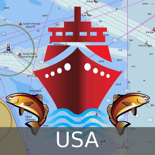
It supports Nautical Charts course up orientation. Includes Tide & Currents prediction. ►FEATURES √ Beautiful and detailed Hardware/GPU accelerated vector charts (text stays upright on rotation) √ Long press to query the details of Marine object (Buoy, Lights, Obstruction etc). √ Customizable depth(Ft/Fathom/Meter) and distance units (km/mi/NM) √ Customizable Shallow Depth. √ Record tracks, Autofollow with real-time track overlay & predicted path vector. √ Voice Prompts for marine navigation (requires GPS ) √ 1ft / 3ft depth contour maps for anglers for selected lake maps. √ Supports GPX/KML for boating route editing/import. √ Tide & Currents prediction. √ Seamless chart quilting of marine charts √ Enter or import Waypoints. ► MAPS The maps include coverage of all NOAA marine vector charts (ENC), USACE inland river maps, and freshwater lake maps for more than 7K lakes. The charts include HD/1ft/3ft bathymetry where available. The app also includes NOAA raster charts for some areas where NOAA ENC coverage is not available. It includes unlimited updates for 1 year. ►ROUTE MANAGEMENT / TRIP PLANNING √ Create New Route/Edit Existing Routes √ Move Points √ Add points to an existing route leg √ Delete / Rename points √ Import GPX, KML & KMZ files √ Plot/Edit Routes √ Enter Waypoints √ Share/Export Routes, Tracks & Markers √ Reverse Routes ►GPS FEATURES √ Auto Follow * Real Time Track Overlay * Predicted Path Vector * Course Up (Text stays upright) * Speed & Heading √ Route Assistance With Voice Prompts * Prompts when approaching a boating route marker * Continous distance and ETA updates * Alerts when sailing/boating off route * Alerts when boating in wrong direction √ Record Tracks ►TIDE & CURRENTS * For US, Canada, UK, Germany & New Zealand * High/Low Tides * Tidal Current Prediction * Active Current Stations ► SHARING * Share tracks/routes/markers on Facebook & Twitter * Export tracks/routes/markers as compressed GPX files. Sample Nautical Charts (please visit http://gpsnauticalcharts.com/main/folio-catalog-nautical-charts-app for complete list) SUGARLOAF KEY-KEY WEST PORT RICHEY TAMPA BAY - CLEARWATER HBR EAST BAY-WEST BAY FLORIDA ST JOSEPH, ST ANDREW BAYS INTRACOASTAL WATERWAY MATECUMBE-GRASSY KEY CHESAPEAKE BAY CAPE CHARLES-NORFOLK HARBOR ANCLOTE KEYS-CRYSTAL RIVER ST JOSEPH SOUND MIAMI HARBOR Minnesota lakes - Kabetogama, Minnetonka, Waconia,Leech,Mille Lacs Lake Keowee,Jocassee,Hartwell,Greenwood,Lake Murray Mark Twain,Ozarks,Table Rock Lake St. Clair Lake Kentucky KEY WEST-THE MISSISSIPPI RIVER SAN PEDRO CHANNEL LAKE MICHIGAN STONY LAKE-POINT BETSIE APALACHICOLA BAY-CAPE SAN BLAS EAST CAPE-MORMON KEY CAPE HENLOPEN-INDIAN RIVER INLET CHESAPEAKE BAY CAPE HENRY-THIMBLE SHOAL LIGHT DULUTH-SUPERIOR HARBOR MONHEGAN ISLAND-CAPE ELIZABETH LAKE ONTARIO - CLAYTON-FALSE DUCKS ISL Lake Winnipesaukee SAN FRANCISCO ENTRANCE MIAMI-MARATHON, FLORIDA BAY CAPE MAY-FENWICK ISLAND MISSISSIPPI RIVER-GALVESTON CAPE CANAVERAL-KEY WEST DELAWARE RIVER WILMINGTON-PHILADELPHIA FLORIDA KEYS SOMBRERO KEY-SAND KEY SAN PABLO BAY RAINY LAKE BIG ISLAND MINN-OAKPOINT ISL ONT INTRACOASTAL WATERWAY - BISCAYNE BAY EVERGLADES NTL PARK - SHARK RVR-LOSTMANS RVR MIAMI-MARATHON & FLORIDA BAY BLACKBURN BAY LAKE HURON LAKE TAHOE STRAITS OF MACKINAC NORFOLK HARBOR & ELIZABETH RIVER SAN DIEGO-SANTA ROSA ISLAND DELAWARE BAY CHOPTANK RIVER CAMBRIDGE-GREENSBORO FORT LAUDERDALE PORT EVERGLADES ST SIMONS SOUND-TOLOMATO RIVER CHESAPEAKE DELAWARE CANAL PLEASE NOTE: Continued use of GPS running in the background can dramatically decrease battery life.

i-Boating: USA Marine Charts
View in App StoreGrow your in-app revenue
while we take care of your subscription management.
Mobile
SDK by Qonversion.
Price Intelligence based on:
213,534
apps aggregated
8,172,290
in-app prices defined
89
main categories
In-App Purchase Price (Subscription or Non-Recurring)
vs. average for the Navigation category, $, by region
Build, analyze, and grow in-app subscriptions
with the most powerful mobile SDK for subscriptions
User Reviews for i-Boating: USA Marine Charts
Horrible for fishing
Don’t waste your money if used for fishing. Even after you buy this AND the fishing add on it will still prompt to upgrade even more for “pro”. Trash. Do your research there are far more useful apps for less money that actually work.
Boat Gps
This is a very good boat navigation program that includes ENCs as well as detailed lake contour maps. Pretty much all the features that you find in a high end chartplotter are included. Very easy to overlay charts over satellite imagery, change depth shading to highlight shallow areas, apply depth offsets. It can even pull off AIS targets from our NMEA network.
Waste of money for N Californians
Zero stars if it was possible. Yeah update coming but when. Live in northern Ca & my location is determined to be in Maine. I only downloaded maps in N Ca but call up any famous N Ca lake & boom you’re taken to East Coast. Pretty much seems to be false app advertising. I would look elsewhere for lake maps.UPDATE: Two maps were updated, thank you. So I’ll give one more star for that. But, I ended up moving on to the Navonics app. $9.99/yr. Navonics works great on my iphone, extremely detailed & saved the day when my buddy’s sonar and GPS stopped working. This one had my location in the Midwest. Getting closer. I appreciate the update for the 2 lakes but needed something that worked better for inland fishing. I found it. I’ll keep this app tucked away in a folder, because it cost so much, but mainly in hopes it improves over time. I’ll play with it periodically to check on it. Until then, I’m sorry, but I had to find a better app.
Excellent small boat charting option!
Moved recently from Florida to Utah. Have encountered a number of nautical challenges transitioning from coastal chart plotter navigation to inland lakes navigation. Garmin & Lowrance both want a fortune for their chart plotter options in both inland and coastal products. This i-boating USA app. Provides fabulous detail on both coastal and inland options for a very, very reasonable price point. Awesome option alternative to big boy price gouging for marine navigation.
Awesome App!
Large font and easy to use. Fish are in trouble!
Amazing app!
Just getting acquainted with this app, and I can’t compare it to other similar ones, but wow, it sure does work. 20$ for all of North America and no other costs. Works great.
Nice and easy. Great buy
My only complaint would be to have the display stay on during operations if the phone is on charger. Other than that the app does the job.
Worked perfect for me
We are avid boaters in Texas and like to try out new lakes. Downloaded the app and headed to Lake Texoma. Huge lake and we didn’t want to get lost or bottom out on a low spot. I ran the app concurrently with my Lowrance and the app was actually better because I could see how the under water terrain changed and could navigate around the low spots through the channels. I was able to set waypoints on fishing hotspots, etc. Just as described.
Decent app
App works most of the time. Great when it does. They still need to add Lake of the Woods and other lakes in northern Minnesota and Canada.
Easy to use marine navigation app
Really easy to use and set up charts for offline use. Download grid make it easy to see what all cells to download and what charts already exist on the phone. Charts look very hi def on the phone and are all vector. Most gps features are a toggle button away. Moving map gps clearly shows the breadcrumb and works very well even for long trips.
Description
This App offers access to NOAA marine vector charts, freshwater lake maps, USACE inland river maps (HD/1ft/3ft bathymetry included where available). First marine GPS app to have route assistance with Voice Prompts for marine navigation. You can create new boating routes or import existing GPX/KML routes.
More By This Developer


You May Also Like


POWER SUBSCRIPTION REVENUE GROWTH
